


<p>				<a href="https://ridingroadsandtrails.com/wp-content/uploads/2018/10/Screen-Shot-2018-10-16-at-10.10.37-PM.png" target="_self" itemprop="url" rel="noopener"><br />
				<img src="https://ridingroadsandtrails.com/wp-content/uploads/2018/10/Screen-Shot-2018-10-16-at-10.10.37-PM.png" alt="Planned Route" itemprop="image" height="1130" width="2698" title="Planned Route" /><br />
				</a><br />
		Planned Route</p>
<h2><strong>Road Trip by the numbers:</strong></h2>
<ul>
<li>5800 miles driven</li>
<li>10 Road Rides, 372 miles, 24,000 feet of climbing</li>
<li>10 MTB Rides, 165 miles, 16,500 feet of climbing</li>
<li>7 National Park System areas visited</li>
<li>10 US States visited</li>
</ul>
<p>				<a href="https://ridingroadsandtrails.com/wp-content/uploads/2018/10/IMG_20180830_155920135.jpg" target="_self" itemprop="url" rel="noopener"><br />
				<img src="https://ridingroadsandtrails.com/wp-content/uploads/2018/10/IMG_20180830_155920135.jpg" alt="Casper MTB Trails" itemprop="image" height="2200" width="3163" title="Casper MTB Trails" /><br />
				</a><br />
		Casper MTB Trails</p>
<h2><strong>Casper Mountain County Park</strong></h2>
<p>Casper Mountain, overlooking Casper, WY offered several nice campgrounds adjacent to a mountain-top MTB trail system that offered several miles of rolling trails. Breakfast at Blue Ridge Coffee on the way out of town was an additional treat with great coffee and amazing breakfasts.</p>
<p><iframe height='405' width='590' frameborder='0' allowtransparency='true' scrolling='no' src='https://www.strava.com/activities/1808666789/embed/b8e2313b6fa59f815dddedbab4a201ae866a41d4'></iframe></p>
<h2><strong>Boysen State Park, Shosoni, WY</strong></h2>
<p>The Tough Creek campground in Boysen State Park was a nice starting point for an out and back road ride to Thermopolis, WY through the Wind River Canyon.</p>
<p>				<a href="https://ridingroadsandtrails.com/wp-content/uploads/2018/10/MVIMG_20180901_090252.jpg" target="_self" itemprop="url" rel="noopener"><br />
				<img src="https://ridingroadsandtrails.com/wp-content/uploads/2018/10/MVIMG_20180901_090252.jpg" alt="Riding toward the Wind River Canyon" itemprop="image" height="1126" width="3469" title="Riding toward the Wind River Canyon" /><br />
				</a><br />
		Riding toward the Wind River Canyon<br />
				<a href="https://ridingroadsandtrails.com/wp-content/uploads/2018/10/IMG_20180901_093747.jpg" target="_self" itemprop="url" rel="noopener"><br />
				<img src="https://ridingroadsandtrails.com/wp-content/uploads/2018/10/IMG_20180901_093747.jpg" alt="Wind River Canyon" itemprop="image" height="3024" width="4032" title="Wind River Canyon" /><br />
				</a><br />
		Wind River Canyon<br />
				<a href="https://ridingroadsandtrails.com/wp-content/uploads/2018/10/MVIMG_20180901_111039.jpg" target="_self" itemprop="url" rel="noopener"><br />
				<img src="https://ridingroadsandtrails.com/wp-content/uploads/2018/10/MVIMG_20180901_111039.jpg" alt="Wind River Canyon" itemprop="image" height="3024" width="4032" title="Wind River Canyon" /><br />
				</a><br />
		Wind River Canyon<br />
				<a href="https://ridingroadsandtrails.com/wp-content/uploads/2018/10/IMG_20180831_191032471_HDR.jpg" target="_self" itemprop="url" rel="noopener"><br />
				<img src="https://ridingroadsandtrails.com/wp-content/uploads/2018/10/IMG_20180831_191032471_HDR.jpg" alt="Camping in Boysen State Park" itemprop="image" height="3120" width="4160" title="Camping in Boysen State Park" /><br />
				</a><br />
		Camping in Boysen State Park</p>
<p><iframe src="https://www.strava.com/activities/1812505044/embed/bc8cd782c9ef49b685289dc0eac1dc65230d7a13" width="590" height="405" frameborder="0" scrolling="no"></iframe></p>
<h2><strong>Johnny Behind the Rocks, Lander, WY</strong></h2>
<p>This is a smaller trail system that offers a nice variety of terrain, views and surprisingly a waterfall in a desert environment.</p>
<p>				<a href="https://ridingroadsandtrails.com/wp-content/uploads/2018/10/IMG_20180902_105919424_HDR.jpg" target="_self" itemprop="url" rel="noopener"><br />
				<img src="https://ridingroadsandtrails.com/wp-content/uploads/2018/10/IMG_20180902_105919424_HDR.jpg" alt="Johnny's Falls" itemprop="image" height="2562" width="2541" title="Johnny's Falls" /><br />
				</a><br />
		Johnny&#8217;s Falls<br />
				<a href="https://ridingroadsandtrails.com/wp-content/uploads/2018/10/strava7126093037973926228.jpg" target="_self" itemprop="url" rel="noopener"><br />
				<img src="https://ridingroadsandtrails.com/wp-content/uploads/2018/10/strava7126093037973926228.jpg" alt="Riding Johnny Behind the Rocks" itemprop="image" height="1011" width="1200" title="Riding Johnny Behind the Rocks" /><br />
				</a><br />
		Riding Johnny Behind the Rocks</p>
<p><iframe height='405' width='590' frameborder='0' allowtransparency='true' scrolling='no' src='https://www.strava.com/activities/1815290740/embed/7d8353ed714388a0cbb9f7fb3835efa634b51ed7'></iframe></p>
<h2><strong>Hoback, WY</strong></h2>
<p>South of Jackson Hole is the small town Hoback. We attempted a ride from Hoback to Alpine Junction along the Snake River. Unfortunately, we cut it short due to the fact that my DI2 battery had run flat. I was unable to use all the gears on my bike and was unsure how much reserve there was remaining until there would be no shifting at all.</p>
<p>				<a href="https://ridingroadsandtrails.com/wp-content/uploads/2018/10/IMG_20180903_104359993.jpg" target="_self" itemprop="url" rel="noopener"><br />
				<img src="https://ridingroadsandtrails.com/wp-content/uploads/2018/10/IMG_20180903_104359993.jpg" alt="Sue along the Snake River" itemprop="image" height="2785" width="2510" title="Sue along the Snake River" /><br />
				</a><br />
		Sue along the Snake River<br />
				<a href="https://ridingroadsandtrails.com/wp-content/uploads/2018/10/IMG_20180903_104814311.jpg" target="_self" itemprop="url" rel="noopener"><br />
				<img src="https://ridingroadsandtrails.com/wp-content/uploads/2018/10/IMG_20180903_104814311.jpg" alt="Snake River" itemprop="image" height="2630" width="3503" title="Snake River" /><br />
				</a><br />
		Snake River</p>
<p><iframe height='405' width='590' frameborder='0' allowtransparency='true' scrolling='no' src='https://www.strava.com/activities/1817191812/embed/cb2ed6721c9b0708b4a7de8521f19f1c3a645878'></iframe></p>
<h2><strong>Tetons National Park, WY</strong></h2>
<p>In addition to all the obvious sightseeing opportunities in the Tetons, the roads in the area are wonderful for road riding, especially early in the morning before tourist traffic builds up. The DI2 was charged up and so were we after the short ride the day before. This turned out to be our longest road ride of the trip. There are plenty of good roads in the area with shoulders that we could have easily turned this route into a full century if time had allowed.</p>
<p>				<a href="https://ridingroadsandtrails.com/wp-content/uploads/2018/10/IMG_20180904_084024599.jpg" target="_self" itemprop="url" rel="noopener"><br />
				<img src="https://ridingroadsandtrails.com/wp-content/uploads/2018/10/IMG_20180904_084024599.jpg" alt="Grand Tetons Entrance" itemprop="image" height="2222" width="3161" title="Grand Tetons Entrance" /><br />
				</a><br />
		Grand Tetons Entrance<br />
				<a href="https://ridingroadsandtrails.com/wp-content/uploads/2018/10/IMG_20180904_095935609.jpg" target="_self" itemprop="url" rel="noopener"><br />
				<img src="https://ridingroadsandtrails.com/wp-content/uploads/2018/10/IMG_20180904_095935609.jpg" alt="Grand Teton Reflection" itemprop="image" height="2814" width="2458" title="Grand Teton Reflection" /><br />
				</a><br />
		Grand Teton Reflection<br />
				<a href="https://ridingroadsandtrails.com/wp-content/uploads/2018/10/IMG_20180904_113937104.jpg" target="_self" itemprop="url" rel="noopener"><br />
				<img src="https://ridingroadsandtrails.com/wp-content/uploads/2018/10/IMG_20180904_113937104.jpg" alt="Signal Mountain Summit in Grand Tetons National Park" itemprop="image" height="3120" width="3341" title="Signal Mountain Summit in Grand Tetons National Park" /><br />
				</a><br />
		Signal Mountain Summit in Grand Tetons National Park<br />
				<a href="https://ridingroadsandtrails.com/wp-content/uploads/2018/10/IMG_20180904_090537301.jpg" target="_self" itemprop="url" rel="noopener"><br />
				<img src="https://ridingroadsandtrails.com/wp-content/uploads/2018/10/IMG_20180904_090537301.jpg" alt="Jackson Lake, Grand Tetons" itemprop="image" height="1662" width="3055" title="Jackson Lake, Grand Tetons" /><br />
				</a><br />
		Jackson Lake, Grand Tetons</p>
<p><iframe height='405' width='590' frameborder='0' allowtransparency='true' scrolling='no' src='https://www.strava.com/activities/1820081770/embed/5d3a3e2945c25f3f1665f764e13e176c1f9d4aed'></iframe></p>
<h2><strong>Yellowstone National Park</strong></h2>
<p>Yellowstone and the surrounding area have an amazing variety of geologic features in and around the main caldera of the super-volcano. The roads within Yellowstone have small or no shoulders, making cycling riskier than other areas, especially with tourist drivers. There is an <a href="http://www.cycleyellowstone.com/road-biking/" target="_blank" rel="noopener">annual organized ride</a> through Yellowstone each Fall that might be worth checking out on another visit to the area.</p>
<p>				<a href="https://ridingroadsandtrails.com/wp-content/uploads/2018/10/DSC_7309.jpg" target="_self" itemprop="url" rel="noopener"><br />
				<img src="https://ridingroadsandtrails.com/wp-content/uploads/2018/10/DSC_7309.jpg" alt="Yellowstone geyser basin" itemprop="image" height="4016" width="6016" title="Yellowstone geyser basin" /><br />
				</a><br />
		Yellowstone geyser basin<br />
				<a href="https://ridingroadsandtrails.com/wp-content/uploads/2018/10/IMG_20180903_195754.jpg" target="_self" itemprop="url" rel="noopener"><br />
				<img src="https://ridingroadsandtrails.com/wp-content/uploads/2018/10/IMG_20180903_195754.jpg" alt="Yellowstone Lake accessed from the Grant Village campground" itemprop="image" height="3024" width="4032" title="Yellowstone Lake accessed from the Grant Village campground" /><br />
				</a><br />
		Yellowstone Lake accessed from the Grant Village campground<br />
				<a href="https://ridingroadsandtrails.com/wp-content/uploads/2018/10/IMG_20180905_082255678_HDR.jpg" target="_self" itemprop="url" rel="noopener"><br />
				<img src="https://ridingroadsandtrails.com/wp-content/uploads/2018/10/IMG_20180905_082255678_HDR.jpg" alt="Old Faithful" itemprop="image" height="2690" width="2490" title="Old Faithful" /><br />
				</a><br />
		Old Faithful<br />
				<a href="https://ridingroadsandtrails.com/wp-content/uploads/2018/10/DSC_7336.jpg" target="_self" itemprop="url" rel="noopener"><br />
				<img src="https://ridingroadsandtrails.com/wp-content/uploads/2018/10/DSC_7336.jpg" alt="Yellowstone Bison" itemprop="image" height="3093" width="3265" title="Yellowstone Bison" /><br />
				</a><br />
		Yellowstone Bison<br />
				<a href="https://ridingroadsandtrails.com/wp-content/uploads/2018/10/DSC_7397.jpg" target="_self" itemprop="url" rel="noopener"><br />
				<img src="https://ridingroadsandtrails.com/wp-content/uploads/2018/10/DSC_7397.jpg" alt="Grand Prismatic Spring" itemprop="image" height="2939" width="5393" title="Grand Prismatic Spring" /><br />
				</a><br />
		Grand Prismatic Spring<br />
				<a href="https://ridingroadsandtrails.com/wp-content/uploads/2018/10/DSC_7390.jpg" target="_self" itemprop="url" rel="noopener"><br />
				<img src="https://ridingroadsandtrails.com/wp-content/uploads/2018/10/DSC_7390.jpg" alt="Grand Prismatic Spring with clouds" itemprop="image" height="3866" width="5791" title="Grand Prismatic Spring with clouds" /><br />
				</a><br />
		Grand Prismatic Spring with clouds</p>
<h2><strong>West Yellowstone, MT</strong></h2>
<p>Just outside the west entrance of Yellowstone is the town of West Yellowstone. There is a cross country ski trail system that doubles as an MTB trail system that offers miles of mellow singletrack. After a day with bus loads of tourists at the Old Faithful area within Yellowstone, the solitude of this trail system was welcomed.</p>
<p>				<a href="https://ridingroadsandtrails.com/wp-content/uploads/2018/10/IMG_20180905_105630541_HDR.jpg" target="_self" itemprop="url" rel="noopener"><br />
				<img src="https://ridingroadsandtrails.com/wp-content/uploads/2018/10/IMG_20180905_105630541_HDR.jpg" alt="Rendezvous trail system, West Yellowstone, MT" itemprop="image" height="2688" width="3613" title="Rendezvous trail system, West Yellowstone, MT" /><br />
				</a><br />
		Rendezvous trail system, West Yellowstone, MT<br />
				<a href="https://ridingroadsandtrails.com/wp-content/uploads/2018/10/IMG_20180905_122716.jpg" target="_self" itemprop="url" rel="noopener"><br />
				<img src="https://ridingroadsandtrails.com/wp-content/uploads/2018/10/IMG_20180905_122716.jpg" alt="Old Cabin in the Rendezvous Trail System" itemprop="image" height="2264" width="3243" title="Old Cabin in the Rendezvous Trail System" /><br />
				</a><br />
		Old Cabin in the Rendezvous Trail System<br />
				<a href="https://ridingroadsandtrails.com/wp-content/uploads/2018/10/IMG_20180905_122121659.jpg" target="_self" itemprop="url" rel="noopener"><br />
				<img src="https://ridingroadsandtrails.com/wp-content/uploads/2018/10/IMG_20180905_122121659.jpg" alt="Riding in Rendezvous" itemprop="image" height="3120" width="4160" title="Riding in Rendezvous" /><br />
				</a><br />
		Riding in Rendezvous</p>
<p><iframe height='405' width='590' frameborder='0' allowtransparency='true' scrolling='no' src='https://www.strava.com/activities/1821715998/embed/e3b0b23e2c8a8fe0cbc15f9c1016206957c8928e'></iframe></p>
<h2><strong>Bear Tooth Pass, MT</strong></h2>
<p>Just outside the northeast entrance of Yellowstone is the Beartooth Highway that connects Cooke City, MT and Red Lodge, MT. The weather did not cooperate for us to traverse this by bike, but the scenery still made it worthwhile to drive. The town of Red Lodge was also a welcome stop for <a href="http://www.eatmastaco.com/" target="_blank" rel="noopener">lunch at Mas Tacos</a>. The beauty and challenge of this road warrants another visit to the area with the goal of making this ride.</p>
<p>				<a href="https://ridingroadsandtrails.com/wp-content/uploads/2018/10/DSC_7342.jpg" target="_self" itemprop="url" rel="noopener"><br />
				<img src="https://ridingroadsandtrails.com/wp-content/uploads/2018/10/DSC_7342.jpg" alt="Beartooth Pass" itemprop="image" height="3403" width="6015" title="Beartooth Pass" /><br />
				</a><br />
		Beartooth Pass</p>
<h2><strong>Beck Lake Park, Cody, WY</strong></h2>
<p>Cody is not really known as much of a bicycling area, but we did find a surprisingly excellent trail system at Beck Lake Park. This system had some nice flow trails with incorporated double jumps and other trails that integrated the natural rock of the land. The trail builders also made good use of directionality with the trails making it easy to navigate the intended loops. There is also a skills park that has different sections for various skill level riders. This was a nice surprise and a lot of fun for a last minute addition to the itinerary.</p>
<p>				<a href="https://ridingroadsandtrails.com/wp-content/uploads/2018/10/MVIMG_20180908_143127.jpg" target="_self" itemprop="url" rel="noopener"><br />
				<img src="https://ridingroadsandtrails.com/wp-content/uploads/2018/10/MVIMG_20180908_143127.jpg" alt="Beck Lake Park" itemprop="image" height="2291" width="3502" title="Beck Lake Park" /><br />
				</a><br />
		Beck Lake Park<br />
				<a href="https://ridingroadsandtrails.com/wp-content/uploads/2018/10/MVIMG_20180908_131225.jpg" target="_self" itemprop="url" rel="noopener"><br />
				<img src="https://ridingroadsandtrails.com/wp-content/uploads/2018/10/MVIMG_20180908_131225.jpg" alt="Beck Lake Park" itemprop="image" height="3024" width="4032" title="Beck Lake Park" /><br />
				</a><br />
		Beck Lake Park</p>
<p><iframe src="https://www.strava.com/activities/1828392693/embed/4e115a49fb7aeab63bfdf2c75916555a5fd57ba2" width="590" height="405" frameborder="0" scrolling="no"></iframe></p>
<h2><strong>Dayton, WY</strong></h2>
<p>Dayton is one of the gateway towns to the Bighorn National Forest. Highway 14 from Dayton up to Sibley Lake is a ride we tried to do on a previous visit but the weather did not cooperate. This time, there was some wind, but otherwise conditions were good.</p>
<p>				<a href="https://ridingroadsandtrails.com/wp-content/uploads/2018/10/IMG_20180909_123454.jpg" target="_self" itemprop="url" rel="noopener"><br />
				<img src="https://ridingroadsandtrails.com/wp-content/uploads/2018/10/IMG_20180909_123454.jpg" alt="View from Bighorn National Forest" itemprop="image" height="2611" width="2658" title="View from Bighorn National Forest" /><br />
				</a><br />
		View from Bighorn National Forest<br />
				<a href="https://ridingroadsandtrails.com/wp-content/uploads/2018/10/IMG_20180909_120432958.jpg" target="_self" itemprop="url" rel="noopener"><br />
				<img src="https://ridingroadsandtrails.com/wp-content/uploads/2018/10/IMG_20180909_120432958.jpg" alt="View from Bighorn National Forest" itemprop="image" height="2193" width="4160" title="View from Bighorn National Forest" /><br />
				</a><br />
		View from Bighorn National Forest<br />
				<a href="https://ridingroadsandtrails.com/wp-content/uploads/2018/10/IMG_20180909_130901453_HDR.jpg" target="_self" itemprop="url" rel="noopener"><br />
				<img src="https://ridingroadsandtrails.com/wp-content/uploads/2018/10/IMG_20180909_130901453_HDR.jpg" alt="Sibley Lake, Bighorn National Forest" itemprop="image" height="2058" width="2814" title="Sibley Lake, Bighorn National Forest" /><br />
				</a><br />
		Sibley Lake, Bighorn National Forest</p>
<p><iframe height='405' width='590' frameborder='0' allowtransparency='true' scrolling='no' src='https://www.strava.com/activities/1831059160/embed/c08adfbb5b65cce478781610e62c9d92ac5c25e5'></iframe></p>
<h2><strong>Sundance, WY</strong></h2>
<p>About 30 minutes west of Spearfish, SD, and 30 minutes east of Devil&#8217;s Tower National Monument is the Black Hills National Forest. Within the national forest and adjacent to the <a href="https://www.campendium.com/reuter-campground" target="_blank" rel="noopener">Reuter campground</a> is the <a href="https://www.mtbproject.com/trail/356852/bearlodge-mtn-classic-epic-course" target="_blank" rel="noopener">Sundance mountain bike trail system</a>. This system offered a wide variety of trails from easy flow to expert level technical descents and climbs. The trails were tough to navigate, but using the <a href="https://www.mtbproject.com" target="_blank" rel="noopener">MTB Project</a> app helped stay on track. The first attempt was good enough to warrant a second ride the next day.</p>
<p>				<a href="https://ridingroadsandtrails.com/wp-content/uploads/2018/10/IMG_20180911_123718890.jpg" target="_self" itemprop="url" rel="noopener"><br />
				<img src="https://ridingroadsandtrails.com/wp-content/uploads/2018/10/IMG_20180911_123718890.jpg" alt="Sundance Trails System" itemprop="image" height="3120" width="4160" title="Sundance Trails System" /><br />
				</a><br />
		Sundance Trails System<br />
				<a href="https://ridingroadsandtrails.com/wp-content/uploads/2018/10/IMG_20180910_140020880_HDR.jpg" target="_self" itemprop="url" rel="noopener"><br />
				<img src="https://ridingroadsandtrails.com/wp-content/uploads/2018/10/IMG_20180910_140020880_HDR.jpg" alt="Sundance Trail System" itemprop="image" height="3120" width="4160" title="Sundance Trail System" /><br />
				</a><br />
		Sundance Trail System<br />
				<a href="https://ridingroadsandtrails.com/wp-content/uploads/2018/10/DSC_7435.jpg" target="_self" itemprop="url" rel="noopener"><br />
				<img src="https://ridingroadsandtrails.com/wp-content/uploads/2018/10/DSC_7435.jpg" alt="Karate Kidding at Devils Tower" itemprop="image" height="3162" width="4627" title="Karate Kidding at Devils Tower" /><br />
				</a><br />
		Karate Kidding at Devils Tower<br />
				<a href="https://ridingroadsandtrails.com/wp-content/uploads/2018/10/IMG_20180911_101440796.jpg" target="_self" itemprop="url" rel="noopener"><br />
				<img src="https://ridingroadsandtrails.com/wp-content/uploads/2018/10/IMG_20180911_101440796.jpg" alt="Sundance Trails System" itemprop="image" height="3120" width="4160" title="Sundance Trails System" /><br />
				</a><br />
		Sundance Trails System<br />
				<a href="https://ridingroadsandtrails.com/wp-content/uploads/2018/10/IMG_20180910_153358661.jpg" target="_self" itemprop="url" rel="noopener"><br />
				<img src="https://ridingroadsandtrails.com/wp-content/uploads/2018/10/IMG_20180910_153358661.jpg" alt="Reuter campground" itemprop="image" height="1945" width="2678" title="Reuter campground" /><br />
				</a><br />
		Reuter campground<br />
				<a href="https://ridingroadsandtrails.com/wp-content/uploads/2018/10/DSC_7412.jpg" target="_self" itemprop="url" rel="noopener"><br />
				<img src="https://ridingroadsandtrails.com/wp-content/uploads/2018/10/DSC_7412.jpg" alt="Devils Tower landscape" itemprop="image" height="2936" width="4924" title="Devils Tower landscape" /><br />
				</a><br />
		Devils Tower landscape</p>
<p><iframe height='405' width='590' frameborder='0' allowtransparency='true' scrolling='no' src='https://www.strava.com/activities/1833109166/embed/55f4ceef979a24486f20cb327847d3108fe36b23'></iframe></p>
<p><iframe height='405' width='590' frameborder='0' allowtransparency='true' scrolling='no' src='https://www.strava.com/activities/1835228599/embed/e08de84dec3b73589f8ce9fa0a52f8a00228e087'></iframe></p>
<h2><strong>Spearfish, SD</strong></h2>
<p>Spearfish is a town known for bicycling, with gravel biking being the most popular form. We&#8217;ll dabble in gravel with our road bikes when we need to from time to time but more often stick to pavement for road riding and singletrack for mountain biking. We had stopped at the <a href="https://www.twowheelerdealer.com/" target="_blank" rel="noopener">Two Wheeler Dealer bike shop</a> to get some info on the local riding and found them to have what it takes to be a great shop. I highly recommend paying them a visit if you are in the area.</p>
<p>While in town we chose the Spearfish Canyon ride which is an out and back route. There is a waterfall at the south end of the canyon that made a good destination.</p>
<p>				<a href="https://ridingroadsandtrails.com/wp-content/uploads/2018/10/IMG_20180912_114153312_HDR.jpg" target="_self" itemprop="url" rel="noopener"><br />
				<img src="https://ridingroadsandtrails.com/wp-content/uploads/2018/10/IMG_20180912_114153312_HDR.jpg" alt="Spearfish Canyon" itemprop="image" height="2535" width="3500" title="Spearfish Canyon" /><br />
				</a><br />
		Spearfish Canyon<br />
				<a href="https://ridingroadsandtrails.com/wp-content/uploads/2018/10/MVIMG_20180912_120223.jpg" target="_self" itemprop="url" rel="noopener"><br />
				<img src="https://ridingroadsandtrails.com/wp-content/uploads/2018/10/MVIMG_20180912_120223.jpg" alt="Bridal Veil Falls, Spearfish" itemprop="image" height="3747" width="2292" title="Bridal Veil Falls, Spearfish" /><br />
				</a><br />
		Bridal Veil Falls, Spearfish<br />
				<a href="https://ridingroadsandtrails.com/wp-content/uploads/2018/10/IMG_20180912_112958186_HDR.jpg" target="_self" itemprop="url" rel="noopener"><br />
				<img src="https://ridingroadsandtrails.com/wp-content/uploads/2018/10/IMG_20180912_112958186_HDR.jpg" alt="Roughlock Falls, Spearfish" itemprop="image" height="3801" width="1731" title="Roughlock Falls, Spearfish" /><br />
				</a><br />
		Roughlock Falls, Spearfish</p>
<p><iframe height='405' width='590' frameborder='0' allowtransparency='true' scrolling='no' src='https://www.strava.com/activities/1837264432/embed/66f97034f5501a553703decb3be087768159ec9c'></iframe></p>
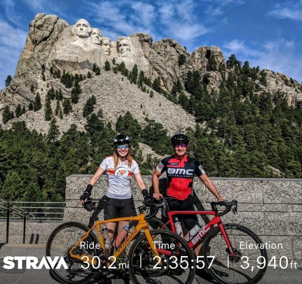
<h2><strong>Custer State Park, SD</strong></h2>
<p>Custer State Park contains a couple of roads that made for two of our favorite rides of the entire trip. With a little more planning, these two could have been a single loop ride. The first road is the Iron Mountain Highway, which is known for its tunnels, pigtail bridges and views of Mt Rushmore. It essentially felt like a giant go-kart track. The second road being the Needles Highway which also has tunnels and leads through beautiful needle-like rock formations.</p>
<p>				<a href="https://ridingroadsandtrails.com/wp-content/uploads/2018/10/IMG_20180913_102640_1.jpg" target="_self" itemprop="url" rel="noopener"><br />
				<img src="https://ridingroadsandtrails.com/wp-content/uploads/2018/10/IMG_20180913_102640_1.jpg" alt="Mt Rushmore" itemprop="image" height="3024" width="3224" title="Mt Rushmore" /><br />
				</a><br />
		Mt Rushmore<br />
				<a href="https://ridingroadsandtrails.com/wp-content/uploads/2018/10/IMG_20180913_095202.jpg" target="_self" itemprop="url" rel="noopener"><br />
				<img src="https://ridingroadsandtrails.com/wp-content/uploads/2018/10/IMG_20180913_095202.jpg" alt="Pigtail Bridge" itemprop="image" height="3024" width="4032" title="Pigtail Bridge" /><br />
				</a><br />
		Pigtail Bridge<br />
				<a href="https://ridingroadsandtrails.com/wp-content/uploads/2018/10/IMG_20180913_094818.jpg" target="_self" itemprop="url" rel="noopener"><br />
				<img src="https://ridingroadsandtrails.com/wp-content/uploads/2018/10/IMG_20180913_094818.jpg" alt="Iron Mountain Tunnel overlooking Mt Rushmore" itemprop="image" height="3024" width="4032" title="Iron Mountain Tunnel overlooking Mt Rushmore" /><br />
				</a><br />
		Iron Mountain Tunnel overlooking Mt Rushmore<br />
				<a href="https://ridingroadsandtrails.com/wp-content/uploads/2018/10/IMG_20180913_092953.jpg" target="_self" itemprop="url" rel="noopener"><br />
				<img src="https://ridingroadsandtrails.com/wp-content/uploads/2018/10/IMG_20180913_092953.jpg" alt="Needles Highway tunnel" itemprop="image" height="1938" width="2447" title="Needles Highway tunnel" /><br />
				</a><br />
		Needles Highway tunnel<br />
				<a href="https://ridingroadsandtrails.com/wp-content/uploads/2018/10/IMG_20180914_100324513.jpg" target="_self" itemprop="url" rel="noopener"><br />
				<img src="https://ridingroadsandtrails.com/wp-content/uploads/2018/10/IMG_20180914_100324513.jpg" alt="Sylvan Lake, SD" itemprop="image" height="2665" width="3340" title="Sylvan Lake, SD" /><br />
				</a><br />
		Sylvan Lake, SD<br />
				<a href="https://ridingroadsandtrails.com/wp-content/uploads/2018/10/IMG_20180914_095719479.jpg" target="_self" itemprop="url" rel="noopener"><br />
				<img src="https://ridingroadsandtrails.com/wp-content/uploads/2018/10/IMG_20180914_095719479.jpg" alt="The Needle's Eye" itemprop="image" height="4160" width="3120" title="The Needle's Eye" /><br />
				</a><br />
		The Needle&#8217;s Eye<br />
				<a href="https://ridingroadsandtrails.com/wp-content/uploads/2018/10/IMG_20180914_095617546_HDR.jpg" target="_self" itemprop="url" rel="noopener"><br />
				<img src="https://ridingroadsandtrails.com/wp-content/uploads/2018/10/IMG_20180914_095617546_HDR.jpg" alt="Needles Highway tunnel" itemprop="image" height="3549" width="2662" title="Needles Highway tunnel" /><br />
				</a><br />
		Needles Highway tunnel</p>
<h2><strong>Badlands National Park</strong></h2>
<p>Badlands is a description of a particular type of land formation caused by erosion where sedimentary rock is exposed. We&#8217;ve seen badlands in other parts of the country, however, the national park provides up close and personal access via the main road through the park. We took this as another scenic road riding opportunity.</p>
<p>				<a href="https://ridingroadsandtrails.com/wp-content/uploads/2018/10/DSC_7458.jpg" target="_self" itemprop="url" rel="noopener"><br />
				<img src="https://ridingroadsandtrails.com/wp-content/uploads/2018/10/DSC_7458.jpg" alt="Badlands National Park Sunset" itemprop="image" height="2723" width="5672" title="Badlands National Park Sunset" /><br />
				</a><br />
		Badlands National Park Sunset<br />
				<a href="https://ridingroadsandtrails.com/wp-content/uploads/2018/10/DSC_7453.jpg" target="_self" itemprop="url" rel="noopener"><br />
				<img src="https://ridingroadsandtrails.com/wp-content/uploads/2018/10/DSC_7453.jpg" alt="Badlands National Park" itemprop="image" height="3918" width="5869" title="Badlands National Park" /><br />
				</a><br />
		Badlands National Park<br />
				<a href="https://ridingroadsandtrails.com/wp-content/uploads/2018/10/IMG_20180916_095721135.jpg" target="_self" itemprop="url" rel="noopener"><br />
				<img src="https://ridingroadsandtrails.com/wp-content/uploads/2018/10/IMG_20180916_095721135.jpg" alt="Bighorn Sheep at Badlands National Park" itemprop="image" height="1732" width="3118" title="Bighorn Sheep at Badlands National Park" /><br />
				</a><br />
		Bighorn Sheep at Badlands National Park<br />
				<a href="https://ridingroadsandtrails.com/wp-content/uploads/2018/10/IMG_20180916_090017746.jpg" target="_self" itemprop="url" rel="noopener"><br />
				<img src="https://ridingroadsandtrails.com/wp-content/uploads/2018/10/IMG_20180916_090017746.jpg" alt="Sue riding Badlands National Park" itemprop="image" height="1036" width="3330" title="Sue riding Badlands National Park" /><br />
				</a><br />
		Sue riding Badlands National Park<br />
				<a href="https://ridingroadsandtrails.com/wp-content/uploads/2018/10/IMG_20180916_071018825.jpg" target="_self" itemprop="url" rel="noopener"><br />
				<img src="https://ridingroadsandtrails.com/wp-content/uploads/2018/10/IMG_20180916_071018825.jpg" alt="Riding Badlands National Park" itemprop="image" height="3120" width="4160" title="Riding Badlands National Park" /><br />
				</a><br />
		Riding Badlands National Park</p>
<h2><strong>Cuyuna, MN</strong></h2>
<p>Cuyuna is an old mining area that has lived past its boom times. A few years ago some folks had the idea to invest in building a mountain biking trail system in order to build the tourism trade. Well, it worked, we visited and spent money in the area because of the mountain bike trail system. Over the last few years, this system has gotten a lot of positive press for many miles of smooth flow trail along side scenic natural and former mining lakes. Our expectations were very high after reading so much positive information about the trail system. We did come away a little disappointed with the trails being overly sanitized, poor selection of directional trails, and lacking variety and technical challenge. It was still a fun day and we were fortunate to get a break in the weather to be able to do the ride.</p>
<p>				<a href="https://ridingroadsandtrails.com/wp-content/uploads/2018/10/IMG_20180918_124844717.jpg" target="_self" itemprop="url" rel="noopener"><br />
				<img src="https://ridingroadsandtrails.com/wp-content/uploads/2018/10/IMG_20180918_124844717.jpg" alt="Directional trails" itemprop="image" height="4160" width="3120" title="Directional trails" /><br />
				</a><br />
		Directional trails<br />
				<a href="https://ridingroadsandtrails.com/wp-content/uploads/2018/10/IMG_20180918_100643254.jpg" target="_self" itemprop="url" rel="noopener"><br />
				<img src="https://ridingroadsandtrails.com/wp-content/uploads/2018/10/IMG_20180918_100643254.jpg" alt="Lake along the Cuyuna trails" itemprop="image" height="1334" width="3662" title="Lake along the Cuyuna trails" /><br />
				</a><br />
		Lake along the Cuyuna trails<br />
				<a href="https://ridingroadsandtrails.com/wp-content/uploads/2018/10/IMG_20180918_103332808.jpg" target="_self" itemprop="url" rel="noopener"><br />
				<img src="https://ridingroadsandtrails.com/wp-content/uploads/2018/10/IMG_20180918_103332808.jpg" alt="Sue at Cuyuna" itemprop="image" height="3120" width="3181" title="Sue at Cuyuna" /><br />
				</a><br />
		Sue at Cuyuna<br />
				<a href="https://ridingroadsandtrails.com/wp-content/uploads/2018/10/IMG_20180918_103844843_HDR.jpg" target="_self" itemprop="url" rel="noopener"><br />
				<img src="https://ridingroadsandtrails.com/wp-content/uploads/2018/10/IMG_20180918_103844843_HDR.jpg" alt="Lake along the Cuyuna trails" itemprop="image" height="3045" width="3744" title="Lake along the Cuyuna trails" /><br />
				</a><br />
		Lake along the Cuyuna trails</p>
<p><iframe height='405' width='590' frameborder='0' allowtransparency='true' scrolling='no' src='https://www.strava.com/activities/1850723895/embed/fb9a9cb91a0e5d6f969cdf529faef9043deea283'></iframe></p>
<h2><strong>The Yoopee, Upper Peninsula, Michigan</strong></h2>
<p>The Upper Peninsula of Michigan is famous for the Pictured Rocks National Lakeshore. After weeks of perfect weather conditions, our luck had run out. Pictured Rocks is best viewed by boat, but the wind and rain had closed down all the boat charters and kayak rentals while we were there. Fortunately, we had found some weatherproof mountain biking trails in Marquette, the biggest town in the UP. The trail builders were smart and left tree roots in place to make the trails bulletproof against the weather. Even in the foul weather, these trails were a blast to ride. In addition to Marquette, we toured the remote area where the Two Hearted River meets Lake Superior as well as Ross Lake which seemed to call. One place we missed on the UP is Copper Harbor which is another great looking MTB trail system&#8230;next time.</p>
<p>				<a href="https://ridingroadsandtrails.com/wp-content/uploads/2018/10/IMG_20180920_144621719_HDR.jpg" target="_self" itemprop="url" rel="noopener"><br />
				<img src="https://ridingroadsandtrails.com/wp-content/uploads/2018/10/IMG_20180920_144621719_HDR.jpg" alt="Pictured Rocks National Lakeshore" itemprop="image" height="4160" width="3120" title="Pictured Rocks National Lakeshore" /><br />
				</a><br />
		Pictured Rocks National Lakeshore<br />
				<a href="https://ridingroadsandtrails.com/wp-content/uploads/2018/10/IMG_20180921_105703.jpg" target="_self" itemprop="url" rel="noopener"><br />
				<img src="https://ridingroadsandtrails.com/wp-content/uploads/2018/10/IMG_20180921_105703.jpg" alt="Bike Art" itemprop="image" height="2210" width="2878" title="Bike Art" /><br />
				</a><br />
		Bike Art<br />
				<a href="https://ridingroadsandtrails.com/wp-content/uploads/2018/10/IMG_20180921_172538.jpg" target="_self" itemprop="url" rel="noopener"><br />
				<img src="https://ridingroadsandtrails.com/wp-content/uploads/2018/10/IMG_20180921_172538.jpg" alt="You know a place is remote when you have to clear the roads yourself." itemprop="image" height="3024" width="4032" title="You know a place is remote when you have to clear the roads yourself." /><br />
				</a><br />
		You know a place is remote when you have to clear the roads yourself.<br />
				<a href="https://ridingroadsandtrails.com/wp-content/uploads/2018/10/IMG_20180922_105844246_HDR.jpg" target="_self" itemprop="url" rel="noopener"><br />
				<img src="https://ridingroadsandtrails.com/wp-content/uploads/2018/10/IMG_20180922_105844246_HDR.jpg" alt="Mouth of the Two Hearted River" itemprop="image" height="3120" width="4160" title="Mouth of the Two Hearted River" /><br />
				</a><br />
		Mouth of the Two Hearted River<br />
				<a href="https://ridingroadsandtrails.com/wp-content/uploads/2018/10/IMG_20180920_145241128_HDR.jpg" target="_self" itemprop="url" rel="noopener"><br />
				<img src="https://ridingroadsandtrails.com/wp-content/uploads/2018/10/IMG_20180920_145241128_HDR.jpg" alt="MIners Castle" itemprop="image" height="3120" width="4160" title="MIners Castle" /><br />
				</a><br />
		MIners Castle<br />
				<a href="https://ridingroadsandtrails.com/wp-content/uploads/2018/10/IMG_20180920_150806846.jpg" target="_self" itemprop="url" rel="noopener"><br />
				<img src="https://ridingroadsandtrails.com/wp-content/uploads/2018/10/IMG_20180920_150806846.jpg" alt="Pictured Rocks National Lakeshore" itemprop="image" height="3120" width="4160" title="Pictured Rocks National Lakeshore" /><br />
				</a><br />
		Pictured Rocks National Lakeshore<br />
				<a href="https://ridingroadsandtrails.com/wp-content/uploads/2018/10/IMG_20180921_114011_1.jpg" target="_self" itemprop="url" rel="noopener"><br />
				<img src="https://ridingroadsandtrails.com/wp-content/uploads/2018/10/IMG_20180921_114011_1.jpg" alt="Ross Riding in Marquette" itemprop="image" height="1565" width="1888" title="Ross Riding in Marquette" /><br />
				</a><br />
		Ross Riding in Marquette<br />
				<a href="https://ridingroadsandtrails.com/wp-content/uploads/2018/10/MVIMG_20180921_172913.jpg" target="_self" itemprop="url" rel="noopener"><br />
				<img src="https://ridingroadsandtrails.com/wp-content/uploads/2018/10/MVIMG_20180921_172913.jpg" alt="More trees to clear" itemprop="image" height="3024" width="4032" title="More trees to clear" /><br />
				</a><br />
		More trees to clear<br />
				<a href="https://ridingroadsandtrails.com/wp-content/uploads/2018/10/IMG_20180922_111626960.jpg" target="_self" itemprop="url" rel="noopener"><br />
				<img src="https://ridingroadsandtrails.com/wp-content/uploads/2018/10/IMG_20180922_111626960.jpg" alt="Lake Superior Shoreline" itemprop="image" height="3120" width="4160" title="Lake Superior Shoreline" /><br />
				</a><br />
		Lake Superior Shoreline</p>
<p><iframe height='405' width='590' frameborder='0' allowtransparency='true' scrolling='no' src='https://www.strava.com/activities/1856612183/embed/20a175b28df30c050eb384b7505f0242aa5329fe'></iframe></p>
<p>				<a href="https://ridingroadsandtrails.com/wp-content/uploads/2018/10/DSC_7472.jpg" target="_self" itemprop="url" rel="noopener"><br />
				<img src="https://ridingroadsandtrails.com/wp-content/uploads/2018/10/DSC_7472.jpg" alt="Ross Lake Swans" itemprop="image" height="3836" width="5746" title="Ross Lake Swans" /><br />
				</a><br />
		Ross Lake Swans<br />
				<a href="https://ridingroadsandtrails.com/wp-content/uploads/2018/10/IMG_20180922_184154161_HDR.jpg" target="_self" itemprop="url" rel="noopener"><br />
				<img src="https://ridingroadsandtrails.com/wp-content/uploads/2018/10/IMG_20180922_184154161_HDR.jpg" alt="Ross Lake campground with a taste of Colorado" itemprop="image" height="4160" width="3120" title="Ross Lake campground with a taste of Colorado" /><br />
				</a><br />
		Ross Lake campground with a taste of Colorado</p>
<h2><strong>Ann Arbor, MI</strong></h2>
<p>Brianna lives in Ann Arbor and there really is no better reason to visit this cool college town. We hung out with Brianna for the day and she gave us a nice taste of life in Ann Arbor.</p>
<p>				<a href="https://ridingroadsandtrails.com/wp-content/uploads/2018/10/MVIMG_20180924_155941.jpg" target="_self" itemprop="url" rel="noopener"><br />
				<img src="https://ridingroadsandtrails.com/wp-content/uploads/2018/10/MVIMG_20180924_155941.jpg" alt="Brianna and Ross" itemprop="image" height="2664" width="2442" title="Brianna and Ross" /><br />
				</a><br />
		Brianna and Ross</p>
<h2><strong>DTE Foundation Trail, Chelsea, MI</strong></h2>
<p>When riding in Marquette, another rider that we had met along the way suggested trying the DTE trails near Ann Arbor since we were headed there. This is another impressively well built trail system with lots of flow but also variety in an easy to navigate layout. There is an adjacent campground, Green Lake Campground that made it convenient for our travels.</p>
<p>				<a href="https://ridingroadsandtrails.com/wp-content/uploads/2018/10/IMG_20180924_090103.jpg" target="_self" itemprop="url" rel="noopener"><br />
				<img src="https://ridingroadsandtrails.com/wp-content/uploads/2018/10/IMG_20180924_090103.jpg" alt="DTE Foundation Trails" itemprop="image" height="3024" width="4032" title="DTE Foundation Trails" /><br />
				</a><br />
		DTE Foundation Trails<br />
				<a href="https://ridingroadsandtrails.com/wp-content/uploads/2018/10/DSC_7474.jpg" target="_self" itemprop="url" rel="noopener"><br />
				<img src="https://ridingroadsandtrails.com/wp-content/uploads/2018/10/DSC_7474.jpg" alt="Green Lake Swan" itemprop="image" height="3036" width="3038" title="Green Lake Swan" /><br />
				</a><br />
		Green Lake Swan<br />
				<a href="https://ridingroadsandtrails.com/wp-content/uploads/2018/10/IMG_20180924_092028483_HDR.jpg" target="_self" itemprop="url" rel="noopener"><br />
				<img src="https://ridingroadsandtrails.com/wp-content/uploads/2018/10/IMG_20180924_092028483_HDR.jpg" alt="DTE Foundation Trails" itemprop="image" height="2523" width="3747" title="DTE Foundation Trails" /><br />
				</a><br />
		DTE Foundation Trails<br />
				<a href="https://ridingroadsandtrails.com/wp-content/uploads/2018/10/IMG_20180923_183612051_HDR.jpg" target="_self" itemprop="url" rel="noopener"><br />
				<img src="https://ridingroadsandtrails.com/wp-content/uploads/2018/10/IMG_20180923_183612051_HDR.jpg" alt="Green Lake Campground" itemprop="image" height="3120" width="4160" title="Green Lake Campground" /><br />
				</a><br />
		Green Lake Campground</p>
<h2><strong>Lake Mills, WI</strong></h2>
<p>Austin &; Amanda recently settled into life in Lake Mills. While they were at work, we headed to their favorite MTB trail system called Camrock. This is another good example of using directional trails to prevent rider conflicts and leaving nature&#8217;s erosion protection in place for sustainable trails. The trail system offered plenty of variety from easy to expert with really good navigation signage.</p>
<p>				<a href="https://ridingroadsandtrails.com/wp-content/uploads/2018/10/IMG_20180925_183855742.jpg" target="_self" itemprop="url" rel="noopener"><br />
				<img src="https://ridingroadsandtrails.com/wp-content/uploads/2018/10/IMG_20180925_183855742.jpg" alt="IMG_20180925_183855742" itemprop="image" height="3120" width="4160" title="IMG_20180925_183855742" /><br />
				</a><br />
				<a href="https://ridingroadsandtrails.com/wp-content/uploads/2018/10/IMG_20180925_103915277.jpg" target="_self" itemprop="url" rel="noopener"><br />
				<img src="https://ridingroadsandtrails.com/wp-content/uploads/2018/10/IMG_20180925_103915277.jpg" alt="Camrock Trails" itemprop="image" height="2224" width="2192" title="Camrock Trails" /><br />
				</a><br />
		Camrock Trails</p>
<p><iframe height='405' width='590' frameborder='0' allowtransparency='true' scrolling='no' src='https://www.strava.com/activities/1865195851/embed/99fb1578bba12881e7c53677a70be2f3a8bd2e87'></iframe></p>
<h2><strong>Madison, WI</strong></h2>
<p>After Lake Mills, we hopped over to Madison. We&#8217;ve heard for so long that Madison is a bicycle friendly town and wanted to experience it for ourselves. Jaret offered up a guided tour that included Madison and the surrounding area. The ride did not disappoint with a nice mix of rural and urban roads and many Madison area landmarks along the way.</p>
<p>				<a href="https://ridingroadsandtrails.com/wp-content/uploads/2018/10/IMG_20180926_122338433.jpg" target="_self" itemprop="url" rel="noopener"><br />
				<img src="https://ridingroadsandtrails.com/wp-content/uploads/2018/10/IMG_20180926_122338433.jpg" alt="Jaret at the UW terrace" itemprop="image" height="2428" width="3072" title="Jaret at the UW terrace" /><br />
				</a><br />
		Jaret at the UW terrace<br />
				<a href="https://ridingroadsandtrails.com/wp-content/uploads/2018/10/IMG_20180926_115424647_HDR-1.jpg" target="_self" itemprop="url" rel="noopener"><br />
				<img src="https://ridingroadsandtrails.com/wp-content/uploads/2018/10/IMG_20180926_115424647_HDR-1.jpg" alt="In front of the capitol" itemprop="image" height="3145" width="2488" title="In front of the capitol" /><br />
				</a><br />
		In front of the capitol</p>
<p><iframe height='405' width='590' frameborder='0' allowtransparency='true' scrolling='no' src='https://www.strava.com/activities/1867393747/embed/b9dd2f918bdd8af1683b8e61665ca2db5de16372'></iframe></p>
<h2><strong>Omaha, NE</strong></h2>
<p>We were looking for one more stop to break up the long ride home. Omaha was a good central point and they had some bicycle friendly verbiage on their web. Unfortunately, once we got there, the promise of miles of bike paths remained unfulfilled with bike path sections unexpectedly dropping riders onto multi-lane highways and other roads that were supposed to have bike lanes that had been over-painted into car lanes. Maybe we chose our route poorly, but this area did not seem interested in sharing their roads with cyclists or providing alternate, non-road routes of any real length for cyclists. We decided to cut this ride short as it seemed too hard to find safe passage through the area by bicycle and still enjoy the ride. Unfortunately for us, we would normally check in with a bike shop for ride info. However, when we decided to make this stop, it was already past business hours and the ride started before business hours the next day. So maybe there is riding gold in Omaha, we did not find it.</p>
<p>Upon further investigation, Strava has expanded the <a href="https://www.strava.com/local/?hl=en-US" target="_blank" rel="noopener">Local Guides capability</a> to include Omaha. Of the routes recommended by Strava, none had recommended the areas where we had ridden. Oh well, maybe next time.</p>
<p>				<a href="https://ridingroadsandtrails.com/wp-content/uploads/2018/10/IMG_20180927_105058968_HDR.jpg" target="_self" itemprop="url" rel="noopener"><br />
				<img src="https://ridingroadsandtrails.com/wp-content/uploads/2018/10/IMG_20180927_105058968_HDR.jpg" alt="Bob Kerrey Pedestrian Bridge" itemprop="image" height="4160" width="3120" title="Bob Kerrey Pedestrian Bridge" /><br />
				</a><br />
		Bob Kerrey Pedestrian Bridge<br />
				<a href="https://ridingroadsandtrails.com/wp-content/uploads/2018/10/IMG_20180927_105510.jpg" target="_self" itemprop="url" rel="noopener"><br />
				<img src="https://ridingroadsandtrails.com/wp-content/uploads/2018/10/IMG_20180927_105510.jpg" alt="Bob Kerrey Pedestrian Bridge" itemprop="image" height="2281" width="3484" title="Bob Kerrey Pedestrian Bridge" /><br />
				</a><br />
		Bob Kerrey Pedestrian Bridge<br />
				<a href="https://ridingroadsandtrails.com/wp-content/uploads/2018/10/IMG_20180927_110107.jpg" target="_self" itemprop="url" rel="noopener"><br />
				<img src="https://ridingroadsandtrails.com/wp-content/uploads/2018/10/IMG_20180927_110107.jpg" alt="MIssouri River flood waters" itemprop="image" height="2622" width="2734" title="MIssouri River flood waters" /><br />
				</a><br />
		MIssouri River flood waters</p>
<p><iframe height='405' width='590' frameborder='0' allowtransparency='true' scrolling='no' src='https://www.strava.com/activities/1869178993/embed/3b1124acbcd1cd26642b67bf791c0b9d04b0bc6a'></iframe></p>
<h2><strong>Sometimes the best views are right out our back door.</strong></h2>
<p>Being on the road is fun with all the riding and exploring opportunities, but being home isn&#8217;t so bad either.</p>
<p>				<a href="https://ridingroadsandtrails.com/wp-content/uploads/2018/10/DSC_7486.jpg" target="_self" itemprop="url" rel="noopener"><br />
				<img src="https://ridingroadsandtrails.com/wp-content/uploads/2018/10/DSC_7486.jpg" alt="backyard view" itemprop="image" height="3052" width="5076" title="backyard view" /><br />
				</a><br />
		backyard view<br />
				<a href="https://ridingroadsandtrails.com/wp-content/uploads/2018/10/DSC_7485.jpg" target="_self" itemprop="url" rel="noopener"><br />
				<img src="https://ridingroadsandtrails.com/wp-content/uploads/2018/10/DSC_7485.jpg" alt="backyard view" itemprop="image" height="3551" width="6015" title="backyard view" /><br />
				</a><br />
		backyard view</p>

Roadtrip – Cycling Wyoming, South Dakota and the upper midwest
Ride to Mt Rushmore